Monday, December 28, 2009

It’s not a black and white photo

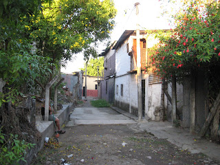
Before I went to El Salvador in 1991 (read why in my earlier post here), I had never traveled outside the US. I had read lots of articles about the country’s Civil War and intense poverty in the LA Weekly, a lefty newspaper in Los Angeles where I went to school.  I imagined El Salvador as a somber, high contrast black and white photo, with some thick red paint dripping down it to represent the bloodshed and suffering of a noble people being crushed by US Imperialism.  (yeah, pretty dramatic)

To my surprise, El Salvador was more of a bright, animated 3-D movie with endless layers of depth and detail.  Continue reading ....

Related posts on Wait... What:
The real story involves anti-social entrepreneurs and anthropology

Wednesday, December 16, 2009

Is This Map Better than That Map?

I come up against a nagging question when I’m thinking about mapping, when I'm talking about the projects I'm involved in, or when I'm working directly with staff and youth in rural communities using participatory mapping methodologies....

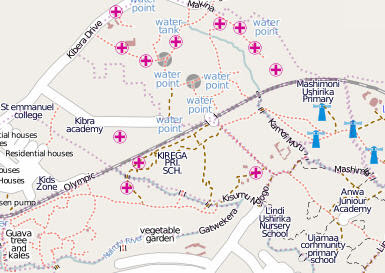
Why is this kind of map:


(source:  MapKibera, on Wikipedia)


better than this kind of map? 


(Source:  Plan project in Kwale, Kenya)


Well... is it actually better?  And if it is better, when is it better, for whom and why?  

I understand how useful mapping information is for big picture decision making, trend spotting and knowledge sharing at different levels.  Mapping in various forms is incredibly useful for program and advocacy work, and there are many examples of how crowd sourcing, digital mapping, and information geo-visualization can be done successfully (mapping stockouts, elections monitoring, human rights incident reporting, crisis management, public health). The potential is huge and exciting.

But when I’m sitting around with a group of people in a rural community without many services, it can be pretty hard to remember or to explain the benefits of digital mapping over low tech map making. Why should people make a digital map if they only have sporadic electricity and internet access (if at all) and not many smart phones.  How will they access that digital map on a regular basis once they make it?  Does the fact that they could make a digital map, necessarily mean that they should? 

I guess my key concern is around how digital mapping is directly useful for the folks who are inputting the information, building the map.  The "what's in it for them" question.  

As I was pondering this nagging question, @NiJeL_mapping posted something on Twitter that caught my eye and helped spur along the idea of working through these thoughts.  He was at the Mobile Data for Social Action in the MidEast conference, hosted by UNICEF Innovations and MobileActive.  He tweeted:  "what data are we going to collect, how will we collect it, and from whom?" Then he tweeted:  "Again, the push for technology w/o any knowledge of the intended outcome is frustrating" And a last tweet "overhearing whispers about how we need to focus on the technology, but impossible w/o knowing info to collect".  This really reminded me that you need to have clear objectives and reasons for collecting data before you decide what cool new technology will be used to do it.  A few days ago I read JD's blog post giving an overview of the whole conference. The key point for me was that the 'target' population delegation "felt overwhelmed by the host of tools and projects presented to them and were unsure how any of this could benefit them". Luckily, he said, the conference organizers realized this and quickly altered the course of the event.

--------------------

Well, if you have ever asked yourself a question, it's pretty likely that someone else has asked it too, and you can find some answers online. So I went digging around for thoughts from 4 initiatives that I've been following over the past year or so: UshahidiMapKiberaWikimapa, and now NiJeL too.

In very quick summary, Ushahidi is often (but not exclusively) used as a crisis mapping tool for rapid crowd sourced information, decision making, and trend analysis. Map Kibera and Wikimapa both use mapping and user-generated media for social inclusion, community voice, community media and community planning. NiJeL works with participatory mapping, bringing it to the web for a variety of geo-visualization uses such as planning, resource allocation, impact visualization and advocacy.  

Mine must be not be a unique query, because I found that Erica from Map Kibera answered it pretty directly a couple weeks ago in a blog post called Maps and the Media "...the question about benefit to those who aren’t online misses the point. The digital divide is a fact and needs to be addressed, but when it comes to community information there is also a need for expression outward and collaboration within Kibera. Something like the Kibera Journal or Pamoja FM allows Kibera to talk to itself, while putting facts and stories online allows it to speak to the rest of the world (including wired Nairobi, politicians, national press)." 


The objectives of Map Kibera seem similar to those of the
 YETAM project, the initiative that has taken up most of my work hours over the past couple years. YETAM's  main goals are engaging youth in the local development process and helping them develop the skills and tools to communicate and advocate for their rights and their ideas with local, national and global audiences.  The project starts off with map making to visualize community profile, community history, community resources, and risks to child rights and protection. Group discussions ensue, issues are prioritized by the youth, and they then create art and media around those issues. The arts and media materials that youth produce throughout the project are shared with community members, district officials and national authorities to generate dialogue. They're also plotted onto a digital version of their map and uploaded to the web for the global audience. 


Since the local audience is the main one for the media and arts that youth produce during YETAM project activities, followed by district, national and global audiences, it would seem then that the same is true for the map. It must first speak to the local audience, to the community.  It should be first useful to users and producers of the information, as a learning/discussion tool and as a decision making tool, and secondly be useful to a national and then a global audience. Perhaps this will be the case for many of the initiatives that Plan supports and facilitates, given Plan's child-centered community develop approach and the fact that we use participatory mapping methodologies in our community work all the time. So we need to find a way for the hand-drawn map to be transformed into a digital map (this is what we've been doing up to now in the YETAM project), or find a way to make a digital map attractive and useful to local people. Or we could also keep doing both the low-tech and the digital versions.

[Update:  "Paper rocks!"  Mikel from Map Kibera (read his comment below) shared some additional tools that Map Kibera uses to ensure that information collected is available in the community.  One is called Walking Papers.  It is a paper based GPS where you print the map, re-draw it or add details, scan the new version and it automatically geo-rectifies the paper.  They will also be printing and distributing paper maps, and considering forums around the paper maps to increase participation from people who don't use computers.  Also Mikel commented that drawn maps like the one in the image above can be stored and/or made available to the community using Map Warper.  Here you scan and upload a map, set control points, and then get a geo-rectified version for use online.  Excellent.  This gets better all the time.  :-)]

The Wikimapa Brazil project (paraphrasing from their website) aims to promote social inclusion using virtual and mobile mapping in low-income areas and slums, since available mapping services have not offered information from these marginalized areas.  The project aims to democratize access to information and raise low-income youth's social participation from simple consumers of information to providers of information and change agents promoting local development and broadening perspectives and creating new cultural and geographical reference points.  In this case, the project goals are similar to YETAM and Map Kibera, but the project is primarily aimed at reducing marginalization and exclusion within available mapping services.  Therefore it seems relevant that on-line mapping is chosen as the mapping methodology.  It may also be the case that residents in the project area have easy access to internet, meaning they would be able to continually use and benefit from the on-line maps.

Patrick Meier from Ushahidi and the Harvard Humanitarian Institute talks specifically about the concepts of participatory mapping, social mapping and crowd feeding during this 30 min video. He comments that the information that's collected via "crowd sourcing" needs to go right back to ‘the crowd’ who provided it (crowd feeding).  One way that Ushahidi is doing this in communities that do not have regular access to internet is by allowing people to subscribe to SMS alerts when a crisis event hits a particular area where they have a special interest.  Another way to ensure that map makers have information returned to them, he says, is to use transparencies in a manual approach to GIS where information is made more compelling by laying thematic transparent layers over a base map to show dynamic changes and trends.

Patrick points to Tactical Technology Collective's Maps for Advocacy booklet which documents a number of different mapping techniques and mapping projects and how they have been used for advocacy.  So, I would conclude that in the case of Ushahidi and crisis mapping to see trends in time and space, to have immediate and up to date information, and to manage a broad set of information for crisis decision making, it also is logical that an online map is the primary mapping methodology.  In this case, the information is crowd sourced, so it comes from many, and it's processed and aggregated on Ushahidi to go back to many.  Because the information in a crisis situation is changing rapidly, it would be difficult to use a static map, a hand drawn map or one that is updated less frequently.  

In the case of Plan, as part of the Violence Against Children (VAC) project we are planning to pilot incident reporting by SMS of violence against children and subsequent mapping of the situation in order to raise awareness among families and community members, and to advocate to local, national and global authorities to uphold their responsibilities and promises in this aspect.  The question here will be how to make both crowd sourcing and crowd feeding something that is easily accessible by the participating youth and communities as well as to the other audiences in order to have the desired impact and reach the desired outcomes. The participating youth have already been trained on violence against children (VAC), its causes and effects, and ways to advocate around it.  Now the key will be training them on the technology so that they can discover and design ways to use it  to meet their goals.  A key point will be evaluating whether the outcome is a reduction in VAC.

So in conclusion I would have to say that one map is not better than the other map.  They are both amazing  tools and need to be selected depending on the situation. There is no one size fits all. It goes back to the point of having defined objectives and outcomes for the initiative, knowing what information will be collected, why, with whom, by whom, and for whom first, analyzing the local context as part of that process, knowing about what tools exist and finding the right tool/technology/information management process for the goals that people want to reach based on the context. It's also about keeping the end-user in mind, and ensuring that those who are producing information have access to that information. I think I will have to keep my question in mind at all times, actually.


Thursday, December 3, 2009

FLAP Power for the Basics: Illumination and Communication


The FLAP Bag is a project that was initiated at PopTech, together with Portable Light and Timbuk2 (join the discussion on FLAP bags here)  The FLAP is a messenger bag, designed by Timbuk2, which incorporates a removable flexible solar panel made by Portable Light.  The solar panel can be left on the bag and charged on the go (i.e. while you walk around in the sun) or removed and laid out flat to absorb the sun.  Connected to the solar panel is a battery that feeds into a small light, useful for walking/riding a bike at night, and a mobile phone charger.... continue reading...

Related posts on Wait... What?:
It's a Light, It's a Bag, It's a Charger... It's FLAP!
Pop!Tech: Oh!

Saturday, November 28, 2009

The real story involves anti-social entrepreneurs and anthropology.

People often ask me 2 questions.  How did I end up spending the 90s in El Salvador and how did I get into NGO work?  I usually give the 140 character verbal version. But the turning point was 20 years ago this week. So here is the longer story.  continue reading....

Related posts on Wait... What?:
It's not a black and white photo

Thursday, November 26, 2009

Mobiles to teach real-world statistics?

Saturday, was the last day of the 2-week Youth Empowerment through Arts and Media (YETAM) workshop with the youth.  Each of the sub-groups had the task of prioritizing 2-3 areas that they wanted to focus on over the next 6 months and developing a basic plan. Continue reading....

Related posts:
On Girls and ICTs
Putting Cumbana on the Map

Monday, November 23, 2009

Being a Girl in Cumbana

Sometimes being a girl is no piece of cake.  For the Youth Empowerment through Arts and Media (YETAM) workshop we hoped to have 50% girls participating, and we ended up with about 15 girls and 40 boys.  The boys raised this on the 3rd day of the workshop (through no prompting by the facilitators).  "Why aren't there more girls here? And the girls who are here, they never talk, they just sit there.” “They don’t have the ambition or the drive to improve themselves so they don’t even come to workshops like this when they have the opportunity”. Continue reading....

Related posts:
On Girls and ICTs
An example of youth led community change in Mali
Breaking it down: Violence against Children
Stories that touch the heart


Saturday, November 14, 2009

Putting Cumbana on the Map--with Ethics

We've completed our first week of arts and media training with around 55 youth in Cumbana, a coastal community some 450 kms north of Maputo, the capital of Mozambique.  If you ever tried to Google Cumbana, you’d find information about a photographer with the same last name or links to tourist hotels at the nearby beaches in Maxixe or Inhambane, and not much else.  We actually did this as part of our Tuesday session on Internet with the youth.  Googling New York was another story.  But why?  Continue reading....

Related posts:
On Girls and ICTs
Being a Girl in Cumbana
Is this map better than that map?


Sunday, November 8, 2009

It's a light, it's a bag, it's a charger! It's FLAP!

When I was at PopTech in October, I saw the solar FLAP (Flexible Light and Power) bag, a joint project of Portable Light, Timbuk2, and PopTech.  It seemed like something that could help make mobiles in program work more feasible for staff, community volunteers, or community health workers. One of the main challenges we find in our work is lack of electricity, to charge phones among other uses. Continue reading....

Related posts:
FLAP power for the basics: illumination and communication
Pop! Tech:  Oh!

Tuesday, November 3, 2009

Inhambane: land of palm trees and cellular networks

Landing in Inhambane, Mozambique, the first thing you see is the blue Vodacom sign:  ‘Welcome to Inhambane – a land covered by palm trees and the best cellular network’.  I don't usually believe ads and this time was no exception. But I have to say, it seems to be true. My sim card is actually on mCel, not Vodacom, but the coverage is still damn good.  And the two cell phone companies are everywhere. I’m not sure which I saw more of – yellow Frelimo t-shirts (elections were last week), yellow mCel kiosks or blue Vodacom kiosks.  Continue reading....

Related posts:
Putting Cumbana on the Map

Saturday, October 31, 2009

Feet back on the ground: Mozambique

I got into Maputo (capital of Mozambique) around 3 on Friday and stopped by the Plan Mozambique office to meet the staff on the way to my hotel. The office here is small. Plan's only been working in Mozambique since 2007 and in one province only so far. Maputo is absolutely gorgeous.  It's calm, not at all crowded, and on the coast.  Continue reading...


Related posts:
Inhambane: land of palm trees and cellular networks

Wednesday, October 28, 2009

Pop!Tech: Oh!

I’m on the train to NYC on the first leg of my journey to Mozambique, toting my new solar FLAP bag and a suitcase full of gadgets. I seem to be somewhere in the middle of nowhere, the rain's pouring down outside and I'm surrounded by red and gold leaves.  The best thing about my insane day so far is that the orange juice I spilled on my keyboard this morning seems not to have done much damage….  But now I have a few hours to stop and reabsorb PopTech.  Continue reading....

Tuesday, October 20, 2009

"It's All Part of the ICT Jigsaw" - Plan Mozambique ICT4D workshops

Plan Mozambique's team has been discussing ICTs in their work using the distance learning packet that my colleague Mika (at Plan Finland) and I put together with lots of support from Hannah Beardon. This is part of our ICT4D research and training initiative in 8 countries (Senegal, Togo, Mali, Cameroon, Ghana, Mozambique, Kenya, Uganda) that will conclude near the end of the year. Continue reading....


Related Posts:
I and C then T
ICT ideas from Plan Cameroon
ICT4D Kenya: ICT and community development is real
Modernizing birth registration with mobile technology
In Kenya brainstorming on mobiles
Chickens and eggs and ICTs

I saw the future of geo-visualization... after lunch

This is the 'after-lunch' part of my last blog about the cool geo-visualization tools I had the chance to learn about at the Google Partnership Exploration Workshop.  Continue reading....


I saw the future of geo-visualization.... before lunch

Last week some 40 people from more than 20 different organizations with national and global humanitarian and relief missions attended a Google Partnership Exploration Workshop in Washington, DC, to share information in an interactive setting and explore how the organizations and Google geo & data visualization technologies can further each others' missions.  Continue reading....


Related posts:
I saw the future of geovisualization… after lunch
Is this map better than that map?
Ushahidi in Haiti:  what’s needed now

Sunday, September 27, 2009

Breaking it Down: Violence Against Children


How do you break down a high level UN study and connect children and youth with the information so that they can use it for their own purposes, engage others and push for a change?  Continue reading....

Friday, September 18, 2009

Girl Power and the CGI!

Next week I’ll have the honor of (wo)manning the expo table for Plan at the Clinton Global Initiative (CGI) Exchange [the networking event after the actual CGI meeting]. It's Plan's first year at the CGI, which is exciting for us as an organization. The project that we’ve committed to is a convergence of many of the things that Plan has been getting deeper and deeper into in the past few years – youth engagement, youth employment, participatory media, social media, ICTs, youth voice, youth-led advocacy, and last but not least, girl power. Continue reading....


Related posts:
On Girls and ICTs
Being a girl in Cumbana
An example of youth-led community change in Mali

Sunday, September 13, 2009

I and C, then T

Last week some Plan USA staff got together at Plan’s Washington, DC office as part of our ongoing discussions on how Plan globally could better use ICTs and social media as enablers in our work and to improve program outcomes.  We had the honor of some amazing minds to support us, including Josh Nesbit (@joshnesbit) from FrontlineSMS: Medic, Dave Isaak from SixBlue Data (@sixblue_data), Michael Downey from Indiana University (@downeym), and Wayan Vota from Inveneo (@wayan_vota).  Continue reading...


Related Posts:
It's all part of the ICT jigsaw: Plan Mozambique ICT4D workshops
ICT ideas from Plan Cameroon
ICT4D Kenya: ICT and community development is real
Modernizing birth registration with mobile technology
In Kenya brainstorming on mobiles
Chickens and eggs and ICTs


Friday, August 7, 2009

Development Education - a relevant term?

I recently participated in some research that an organization is doing to update its Development Education strategy. One of the questions during the interview was whether the term ‘development education’ is relevant anymore, and for whom. It made me think about a comment I recently came across asking if people in ‘developing’ countries use the term ICT4D or just call it ‘ICT.’

Development Education is often used to describe different activities that development organizations do ‘in the North’ to educate donors, students, and/or the public in general about the realities of the “developing” world. It aims to help people better understand ‘good development’ and to get them to make personal choices that would contribute to ‘good development’ overseas (eg., voting, purchasing or consuming differently, supporting policies that offer certain benefits to the developing world, volunteering, ‘spreading the word’, etc.).

Development Education can be used to prime or soften people up for advocacy campaigns and concrete actions. It can be directed at large donors when organizations are attempting to get them to change policies or funding habits. It can be part of the school curriculum, created in a way that maintains a middle ground, but prompts students to think about issues and choices faced in development or the global context (see Choices for the 21st Century Curriculum). And some governments give grants out under the category of 'development education' when they are funding organizations to ‘educate’ people overseas about how friendly and generous the donor country and their policies and people are.

In most cases, I think the concept of Development Education is a good one. It helps people understand the broader picture, the structural causes of poverty, cultural relevance, why hand-outs are not the way to go, why local ownership is important, and why the way people do things ‘here’ isn’t necessarily the way people should do things ‘there’. It helps scratch under the surface of advocacy campaigns so that people better understand why they are signing something or clicking on that email to their senators. It can be a way of bringing examples of good practices and real situations to large donors to change their perspectives on what they donate to based on concrete experiences rather than hyphotheses and theories or the latest trends.

Development Education seems especially important in the US where people often give out of a charity mindset or guilt; where they are bombarded daily with pathetic images of starving children who can be fed for just 50 cents a day; and where stories of American heroes who go off to 'solve' problems for those living in other places get more airtime than stories of capable people in other countries resolving things on their own. It has a place with US young people who don’t have access to much global education in the classroom because standardized tests focus on the 4 basics. (As opposed to the UK, for example, where schools are mandated and funded to offer topics that provide global perspective on global issues). Yes, in the US there is very likely a place for something along the lines of 'Development Education'.

But can a global organization talk about 'Development Education' in a way that is relevant across all countries where it’s working? And if so, what would be the common term? What constitutes Development Education 'in the South' and is it even a relevant concept? Can development education be separated from civic engagement, advocacy and political processes? I have some thoughts around this, but haven't hit on one that convinces me enough.... I'm sure I could just google it, but what would be the fun in that?

Wednesday, August 5, 2009

@MambeNanje and company

I wrote last week about Mambe Churchill Nanje and his work with Village Diary in Cameroon. But Village Diary is not Churchill’s whole story. The other part is his company Afrovisiongroup.com and the company he was keeping when we met up for a Malta and some Castels. Photo: Churchill and Steveslil.

AfroVisioN is Churchill’s IT firm, based out of Buea, Cameroon. AfroVisioN helps local businesses build their on-line presence, and aims to help Cameroon in general realize the potential of the web. “I was in the process of trying to get a nice paying job in IT, and someone told me: ‘Don’t get a job, create jobs instead!' so that’s what I set out to do. I wanted to show people in Cameroon that there is more online than email.”

AfroVisioN invests in research and development to cut down costs of technology to serve the local markets. They provide affordable websites and web solutions, building software packages and automated operations to facilitate management and efficiency.

Although he can’t be more than 24 years old, this is not Churchill’s first venture. In 2006, at age 20 he invested all his time and money in building up a portal to allow students to see their GCE scores online. He purchased the GCE scores from the GCE board and published them for free on a site called passgce.com. The site was promptly shut down by the GCE board. Churchill recognized that there are potential disadvantages to having the scores on the internet (an error in programming logic could show the wrong results or someone could hack into the system and change the results), but that these are easily overcome with standard security measures. He's sure the site was closed for other reasons. “Imagine building all your hopes on something and it gets shut down….”

Not one to give up, Churchill moved on to doing small IT projects that led him to his current business model at AfroVisioN. “Our market and its people don’t have huge financial backings, but they need technology in order to make their businesses more profitable,” so the business model builds on making a web presence affordable.

But Churchill’s goal doesn’t end there. “I kept wondering, why am I exporting software and my schoolmates and family are exporting cocoa… and not earning any money through their hard work.” So Churchill’s broader goal is to make a name for himself, to earn trust and credibility so that he can attract investment to help others to progress. In addition, he’s looking for ways that IT, especially internet, can be used to gain access to information to improve farms and local businesses so that they can earn more.

As we sipped our drinks and then rode in a crowded taxi from one side of town to the other, Churchill’s friends Steveslil and Peter also talked about their aspirations. Photo: Steveslil, Peter and Churchill.

Steveslil is an up and coming R&B singer – check out his website (powered by AfroVisioN) at http://www.steveslil.com/flashsite.swf. He was appointed CEO of CoreSouth Records in 2005 and put out his debut album “Play my Tambourine,” fostered by Churchill, who also directed 2 of Steveslil’s videos. Steveslil is now on the BEI (Bebum Entertainment Industry) label out of Washington DC, founded in 2002 by Cameroonian-American businessman Esapa Sebastien.

Peter (@foch4T) studied at university with Churchill and they currently call on each other when there is work to be done on websites or other IT projects. Peter’s dream is to start a tour company to bring people to Cameroon. “Cameroon is the center of the world. It’s the heart of Africa. Here you have every climate, every type of thing that can be found in Africa, but all in one place.” Peter wants to bring people to Cameroon to experience the country’s beauty and culture in the most real way possible, giving them custom made tours.

Some impressive guys, to say the least. And to me, it was most heartening that not one of them talked about wanting to leave Cameroon to try to succeed elsewhere, but rather building up their country’s own potential and their own people.

Tuesday, July 28, 2009

ICT4D Ideas from Plan Cameroon

I had a chance to meet with Plan Cameroon's Program Technical Team today (including those that look at Monitoring and Evaluation, Health, Education, Sponsorship, Child Protection, Water and Sanitation, Gender and the overall Program Support Manager) to give a quick brief on the ICT4D research and training that Plan Finland is supporting with Plan offices in 8 countries in Africa (Mali, Senegal, Cameroon, Ghana, Togo, Mozambique, Kenya and Uganda).

We are working with Hannah Beardon, who wrote Plan's Mobiles for Development guide (available in both English and French) and building on that towards some more focused and concrete ideas for ICT use in these 8 countries. We'll share the research with staff during 2-day workshops to brainstorm and gather ideas on information and communications needs, as well as available tools that could be used or adapted to local situations.

The 2-day workshops are planned for Aug and Sept. Hannah, Mika (Plan Finland) and I are developing the methodology and will make a training DVD to send ahead of time to each country (apparently complete with our selves doing presentations!) since we don't have funding to do face-to-face training. We'll have a staff person in each country as the main facilitator, and 10-12 key staff, from management to frontline, will attend. Mika or I will beam in by skype to support if needed. We'll use the Frontline SMS demo video that Mika and crew did also, (see my earlier post about this from a few months ago), show how Nokia Data Gathering Software works, share the Common Craft Social Media videos, among other things. Hannah's methodology will also come in for thinking about how ICTs could enhance existing efforts.

The idea is to both learn about new tools as well as look at current programs and see if there are ways to use ICTs to improve impact, and how to begin tailoring them to the programs and local settings. We're also doing research on government policies and how Plan's work links there. I hope that we can also look at partnering with local developers and ICT4D innovators in each country....

The idea of ICT4D was a bit new to some of the Plan Cameroon staff and not at all new to others. One interesting idea they shared was using SMS in anti-malaria programs to periodically remind people to retreat their bednets. There was some concern about literacy rates if one relies on SMS, and interest in using voice response, but given the number of languages in Cameroon, voice could also be a bit of a challenge. I'll have to try to find out if/how that's overcome in other places. Another concern was 'scamming' and how to avoid that happening. But it seemed that the issue of scamming is not something that Plan alone would face, but something in general that is faced with mobile phones.

The program support manager was really keen on using mobiles for program monitoring as that is something that can always improve and be more efficient with ICT, he said, and wants to test some ideas. The ICT manager also said he wanted to write something up. The sponsorship manager suggested trying out some data collection or quicker communications tools for linking with community volunteers. And as mentioned earlier, child media and child protection are areas that can be greatly enhanced and supported via ICTs (help lines, SMS incident reporting, social media and mobile reporting).

After the 2-day workshop, we should have something really nice to go forward with.
Monday, July 27, 2009

Mambenanje and the Village Diary Project

Before I left for Cameroon, I had started doing a little of my own research via blogs and Twitter to learn a bit more about ICT4D in the Cameroonian setting. I wanted to get a feel for what the situation was so I'd be more in tune and also to see if there were any potential partners or people on the ground who I could learn from or link with Plan Cameroon. In the end, I was able to meet with Mambe Churchill Nanje the founder of http://www.afrovisiongroup.com/ and a partner on http://www.villagediary.org/, a project of the LINK-UP development group. Photo: Mambe Churchill Nanje of AfroVisioNgroup.

Since I'm coming from a non-profit and child rights background (at Plan International), and since we are looking into ICT4D as an enabler and facilitator for existing program work, and since much of our work centers on HIV/AIDS, memory books, birth registration, participation and child protection, I especially like the idea behind village diaries. This is some really interesting stuff on several fronts. The mission of the Village Diary project (summarizing from their website here) is "to enhance access to legal, social and health services for orphans, vulnerable children and widows experiencing different forms of abuses. It also serves as a platform to track the cultural and historical background of families and villages."

By supporting the establishment of marriage licenses, birth certificates and last wills and testaments and providing secure access to digital backups of these documents to authorized case workers, Village Diary aims to alleviate the problems that arise after the death of a leading family member. Village Diary also collects stories by women and children to provide a forum for making change and at the same time offers a window into community life.

Village Diary does this by operating an online database that documents and shares cases of abuse of women and children for education, research and advocacy purposes, establishing institutional partnerships to enhance legal, social and health services and facilitate access of such services to orphans and women, strengthening existing support networks for women in the community, and recording cultural, environmental and historical changes of the people and villages involved in the project.

So on top of being involved in some very cool projects, Churchill is also a very cool guy and it was great to have the chance to hang out with him and a few friends on Saturday in Yaounde. Thanks, Twitter (and ourman, billzimmerman, and downeym!). I'm looking forward to seeing where this guy is in a few years, as he has some fantastic ideas for IT in Cameroon.